Skip to content
Would you like to visit your local site?

Australia

We noticed you’re located in New Zealand. There isn't a local site available. Would you like to visit the Australian site?

Australia

Would you like to visit your local site?

Belgium

Would you like to visit your local site?

Canada

Would you like to visit your local site?

China

Would you like to visit your local site?

Italy

Would you like to visit your local site?

Mexico

Would you like to visit your local site?

Netherlands

Would you like to visit your local site?

UK

Would you like to visit your local site?

France

Would you like to visit your local site?

Japan

Skip to Navigation

Across the Landscape

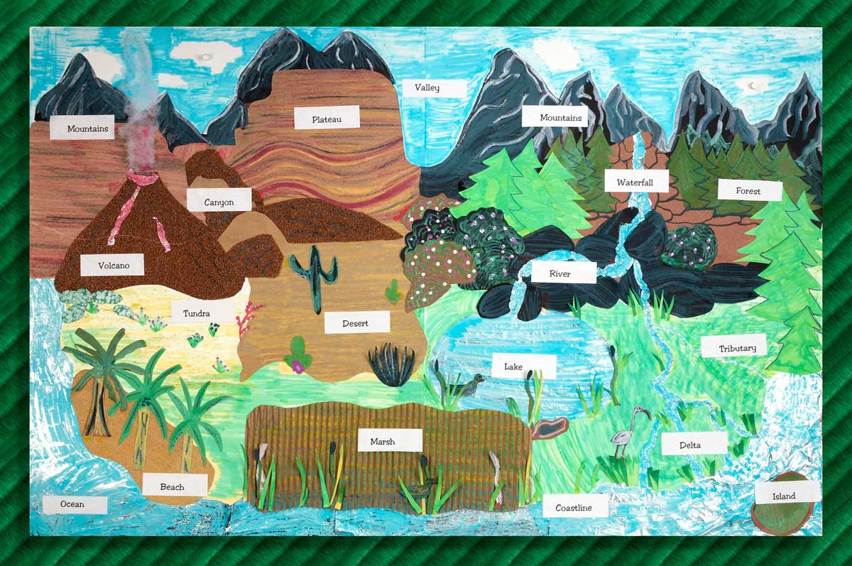
Create a unique, stunning display of the Earth’s landforms. Showcase learning with textured materials such as sandpaper, aluminum foil, and corrugated paper.

  • Grade 2
    Grade 3
    Grade 4
    Grade 5
  • Multiple Lesson Periods
  • Directions

    1. Invite students to find out about the many different types of the Earth’s landforms such as deserts, mountains, oceans, plateaus, coastlines, and marshlands. What characteristics make each of them unique? With a small group of classmates, design a huge bulletin board to highlight what you’re learning.
    2. When creating a background, ask students to overlap big pieces of poster board. Hold the seams together with Crayola® School Glue. Air-dry the background.
    3. Encourage students to be creative with Crayola Erasable Colored Pencils while sketching various areas of landforms on their backgrounds.
    4. Be certain that children choose materials that best portray the textures of each area. For instance, sandpaper is great for deserts or plateaus. Aluminum foil makes shiny water. Consider corrugated paper, cotton balls, and other items, too.
    5. With Crayola Gel Markers, color in areas such as sky, evergreens, and coastline.
    6. Using Crayola Scissors, cut out pieces of textured materials such as sandpaper, aluminum foil, or corrugated paper. Glue them in place on the landscape.
    7. Gel Markers write on many surfaces. Color aluminum foil blue to represent water. Try these markers on sandpaper and other surfaces for a unique look.
    8. Draw objects such as animals, grasses, wildlife, rocks, cacti, and mountain ranges with colored pencils on construction paper. Color them, cut them out, and glue on the bulletin board landscape.
    9. Write labels for the landforms. Cut them out and glue in place. Invite your friends and families to see your magnificent display of what you learned about the Earth!
  • Standards

    LA: Draw on information from multiple print or digital sources, demonstrating the ability to locate an answer to a question quickly or to solve a problem efficiently.

    LA: Engage effectively in a range of collaborative discussions (one-on-one, in groups, and teacher-led) with diverse partners and texts, building on others’ ideas and expressing their own clearly.

    LA: Write informative/explanatory texts to examine a topic and convey ideas and information clearly.

    LA:Adapt speech to a variety of contexts and tasks, using formal English when appropriate to task and situation.

    MATH: Know relative sizes of measurement units within one system of units.

    SCI: Decide what data are to be gathered, what tools are needed to do the gathering, and how measurements will be recorded.

    SCI: Use grade level appropriate understanding of mathematics and statistics in analyzing data.

    SCI: Construct drawings or diagrams as representations of events or systems.

    SCI: Solve design problems by appropriately applying scientific knowledge.

    SS: Locate and distinguish among varying landforms and geographic features, such as mountains, plateaus, islands, and oceans.

    VA: Use different media, techniques, and processes to communicate ideas, experiences, and stories.

    VA: Use visual structures of art to communicate ideas.

  • Adaptations

    Students research a particular landform and the climate in the surrounding land. Students also research what plants and animals inhabit the landform and discover how these life forms are able to thrive in this location. Students can create a diorama of the landform and represent each of the life forms that exist there, labeling each life form. A 1-2 paragraph written summary should accompany the diorama and can be attached to the back of the box.

    Students research landforms of a particular country or continent. Using a student-created map of the country or continent, students will locate and identify the type of landform (ex. Mountain), its name (Appalachian Mountains), statistical information (ex. highest and lowest elevations), and one additional interesting fact about the landform. This map can be posted in the classroom or school hallway for viewing and subsequent student discussions.

    Students research global warming and its effects on landforms of their community, state, or country. Students prepare a news release, reporting on the causes of global warming and their effects on local landmarks. This new release can be video-taped and saved to a classroom computer for viewing.

    Students can write a business letter to a well-known environmentalist, asking for information about global warming in their neighborhoods and what they, as global citizens, can do about lessening the effects. This letter should be word processed and formatted appropriately. When a response is returned, the student(s) can share the expert's findings with classmates.

X

Share this Lesson Plan

Back to top