Skip to Main Content

Giant-Size Outdoor Map

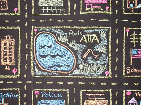
Students will create a large-scale outdoor map using sidewalk chalk.

Lesson Plan

Supplies Needed

Gather all the supplies needed to bring your craft ideas to life! From paints and markers to glue and scissors, our crafts section has everything to spark creativity and make every project truly special.

Steps

  • Step 1

    Have students think about and list the features found in a town or city. What is the difference between a town and a city? How are each administered? What infrastructures are likely to be found in each? Have students look at a map of a city or town near them. Or perhaps the school is already in one of these regions.

  • Step 2

    Divide the class into small groups and have each pick an area to represent. Ask them to first sketch their section on paper. Encourage them to include the buildings, parks, roads, and other features in their area.

  • Step 3

    Select an appropriate place outside that is safe from traffic where students can create a giant map using sidewalk chalk. Have the groups align their sections so all the drawings form a whole picture of the region.

  • Step 4

    They should align on the scale and perimeters so the roads and objects' locations will be consistent as each group illustrates their section. Label the buildings, roads, and other landmarks and add a compass icon to indicate the cardinal directions.

Standards

SS: People, Places, and Environment: Use maps and other geographic representations, geospatial technologies, and spatial thinking to acquire, understand, and communicate information.

SS: People, Places, and Environments: Draw upon experiences in neighborhoods, towns and cities, states and nations, as well as peoples and places distant and unfamiliar to explore geographic similarities and differences.

Adaptations

Have students explore website features such as Google Earth's Geo Tools, where they can take underwater tours of the world's oceans and watch a time-lapse video of melting glaciers or urban expansion, or NASA Worldview, where they can visually explore the past and present of the planet from a satellite's perspective.

Have students research the capital of their state or region and its government. Who are their state and local representatives and congress people? What are some of the services provided by the region? What are its main revenue sources?